 The second edition of the book “Armenia in world cartography” was published at the initiative of Archbishop Yezras Nersisyan, the head of the Nakhichevan-on-Don diocese of the Armenian Apostolic Church, and thanks to the support of Vartan Vartanov.
This undertaking was blessed by Catholicos of all Armenians Garegin II: “From the religious center of the whole Armenian nation, the Mother See of Holy Etchmiadzin, we bring our Patriarchal blessing on the republishing of the valuable work ‘Armenia in world cartography’”.
Ruben Galchyan, the author of the book, a specialist of the history of Armenia and the countries of the Caucasus, a geographer and cartographer, was born in Tabriz to a family of Armenian refugees who had escaped the Armenian Genocide. His first work “Historical maps of Armenia” was published in 2004. This book consisted of maps found by Galchyan in libraries and museums all around the world.
Among his next works are “Armenia in world cartography”, “Countries south of the Caucasus on medieval maps. Armenia, Georgia, and Azerbaijan”, and many others. His last book is titled “Azerbaijani historical-geographical falsifications.”
In his “Armenia in world cartography”, Galchyan included maps of Armenia along with their descriptions and research, which contributes to the understanding of the political development of the ancient and modern worlds and reflects international relations on various stages of governmental development. The book-research puts a clear barrier between reality and fiction and sheds light on the historical truth which Azerbaijan and Turkey now attempt to distort.
“I chose the maps featured in the book in accordance with the following principles,” writes Galchyan in the introduction of the book, “Firstly, the map needs to have cartographic value. Secondly, it needs to be a significant exemplar of the contemporary cartography and reflect its best features.
Examining maps, we conclude that there are only two countries that had existed in the region for over 2,600 years: Persia (Iran) and Armenia. The name “Turkey” first appeared on maps in the 14th century, 2,000 years later than Armenia. As for Azerbaijan, it appears on maps only in 1918.”
The oldest preserved map depicts northern Mesopotamia, which was imaged by Babylonian clay plates in ca. 3,800 BC. The scheme of land plots used by King Sargon to collect tribute in ca. 2300 BC is chronologically the next map.
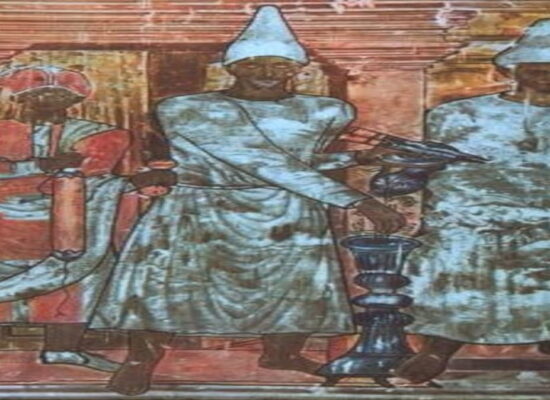
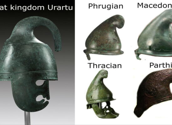
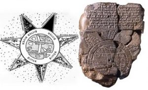
The most ancient map of Armenia is portrayed on a Babylonian clay tablet made in ca. 600 BC, which is now kept at the British Museum in London. It is a spherical map, which portrays Earth as a disc floating on the surface of the sea, in the middle of which is Babylon surrounded by two other countries named Assyria and Urartu (Armenia). This map also portrays the River Euphrates that runs from the mountains of Armenia through Babylon and swamps of Mesopotamia to fall into the Persian Gulf. The seas are marked as “bitter” waters, while the earth is surrounded by 7 islands described on the reverse side of the plate.
From the following historical period, we received fragments of papyruses with schemes of what seems to be cities and districts. Also preserved are the carvings on the tomb of one of the Egyptian pharaohs depicting the flow of the Nile through Egypt, as well as other similar scenes.
We don’t have precise data about the geographical, astronomical, and cartographic knowledge of our ancestors who built the Stonehenge on the British Isles and Zorats Karer in Syunik Province, Armenia. Those two quite similar structures, as well as the Metsamor observatory testify that our ancestors observed and studied the space and its stars, using the latter for navigation and also for the explanation of natural phenomena.
According to Ancient Greek historian and geographer Herodotus (489 – 425 BC), Aristagoras of Miletus during his stay in Sparta showed a map cut out by him on an iron plate and proposed to use it to carry out a campaign to Persia. This map indicated Lidia, Phrygia, Cilicia, Cyprus, Armenia, as well as Susa, a key Persian city. According to Herodotus’ clarification, the map included the region of the Middle East, Iran, and Armenia.
Read also: Armenia on Ancient Maps of the World, Drawn Maps