 In European (English, German) written sources (X–XII cc., XV and even XVIIIc.) it is stated that the ancestors of European people have Armenian origin. The names Armenia and Ararat are mentioned with love and pride. Ancient maps also testify about the fact that Armenia is an ancient country.
The well-known ancient maps of the world, drawn on brick, tin plate, clay, parchment and paper, also prove that Armenia is one of the ancient countries of the world and Armenians are the ancient inhabitants of the world and of South-Western Asia.
Almost on all medieval maps, drawn according to the works of historians, geographers and travelers, Armenia (Greater Armenia, Lesser Armenia), Cilician Armenia and Mount Ararat with Noah’s Ark are always indicated. Let us introduce some of the ancient and medieval maps.
On one of them, the Land of Creation, the Armenian Highlands surrounded by mountains, is indicated in the center with a swastika, symbol or sign of the Creator (god Ar). Four rivers originate from the mountains like the four rivers of the Heaven in the Bible. The mother Earth is surrounded by World Oceans, where 12 fi sh swim.

The images of the Universe and Mother Earth (Mesopotamia, the Armenian Highlands) are indicated on a clay tile, which is a Sumerian map dating back to the middle of the 3rd millennium B.C. On it one can see the Universe, the World Ocean, the Mother Earth on a floating smooth and oviform ground, with its underwater part and seven firmaments.
At the bottom one may depict an entrance, a gate as well, from which the Universal or the Underground River is originated. The Tigris and the Euphrates rivers are supposed to have originated from the springs of this Underground River. Mountains can also be seen there.
The Armenian Highlands and Mesopotamia are presumed to be located there too. Mother Earth is covered with seven firmaments which symbolize the Moon, the Sun and the five planets known at the time.

Another ancient map is the Babylonian stellate map drawn on a brick (6th c. B.C.). The Babylonian stellate map with geographical names on it is the fi rst well-known map in the world. The world is represented as a fl eating disc in the sea.
The map is surrounded by salt water and there are seven islands on it. On that map Armenia is indicated in the northern territory from Mesopotamia, and it borders with Babylon and Assyria in the southern part. On the upper right side of the map the word Armenia is written.
The Euphrates River is originated from the mountains. Assyria, Babylon and seven cities including Habban, Derri, Bitlakina and other cities are also indicated on the map. The islands are in a triangle shape and the Sun, the Moon as well as the fl ora and fauna are indicated on them. Today only Armenia exists from the above mentioned countries and cities.

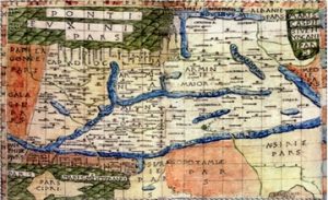
Engraved on a copper tin, one of the ancient maps in the world is the one drawn by Hecataeus of Miletus (517 B.C.) The map was later re-drawn by John Marin (cartographer) and Zatik Khanzadyan (draughtsman). On it Asia, Europe, Libya (Africa) and a number of other countries, including Armenia in the middle of the Mediterranean, the Black and the Caspian Seas, are indicated.114

On the World map drawn by cartographer John Marin and draughtsman Zatik Khanzadyan on the basis of Herodotus’ “History” (5thc. B. C), Armenia is indicated in between the springs of the Tigris and the Euphrates Rivers.

On another World map drawn by the German cartographer Karl von Sprunner in 1855 on the basis of information provided by Eratosthenes (276–194 B.C.), Armenia is indicated in between the Mediterrenean, Black and Caspean Seas. Armenia occupies a central position being situated between Europe and Asia.

On yet another World map drawn by Petrus Bertius in 1630, according to the Greek geographer Posidonis (1st c. B.C.). Armenia is indicated in the center of the map, between Europe and Asia.

The world map drawn by John Marin on the basis of Strabo’s ’’Geography’’ (63 B.C.-20 A.D.). Armenia is again indicated in the center of the map, between Europe and Asia.

On the ancient map of the Middle East in the chapter ‘‘The Situation of the Garden of Eden’’ of the Bible (London, 1599) the following are indicated: Greater Armenia in the springs of the Tigris and the Euphrates Rivers, Mesopotamia, Babylon, the Persian Gulf and some countries.
At present the book is preserved in the library of Lewis & Clark College in Portland in the US State of Oregon. It was revealed by one of the college students. CBC news announces that in the book there is a note asserting that it belonged to Elizabeth I of England and William Shakespeare.

On the map (map 17) found in the book “Geography” by Ptolemaeus (2nd c.), published in Rome in 1482, Greater Armenia and Lesser Armenia (Armenia Minor) are represented together. The seas are in blue and the mountains in green. The important cities of Armenia, Armavir, Artashat and Yervandashat, are also indicated.

On “The third map of Asia” in the book “Geography” by Ptolemaeus (2ndc.), published in Ulm in 1482, Greater Armenia and its neighbouring countries, Colchis, Iberia and Albania are indicated.

On the World map by the Roman geographer Pomponius Mela (43 A.D.) the continents Asia, Europe and Africa as well as a number of countries, including Armenia, are indicated. Armenia is on the upper left side, betweeen Europe and Asia. The East (Asia) is on the upper part.

On the 11th century duplicate of the map by Archbishop Isidore of Seville (570–636) the East is on the upper part. The Mediterranean Sea with numerous islands is in the center, the Red Sea is wedge-shaped and is indicated in red. The mountains are on the upper left side of the map, above them near the images of fl ora (Earthly Heaven) Armenia is written.

On the 12th century handwritten map in the work ‘‘Apocalypse’’ by Beatus of Liébana the Mediterranean Sea is indicated by a perpendicular and blue line. The East is on the upper part, where the image of Earthly Heaven with Adam and Eve is drawn. In the upper central part, on the left of Eve, near the green tree (Earthly Heaven) Armenia is written.

The “Cotton” map was formed in England in the 10th century. On it the East is on the upper part. The Mountains are in green, the seas and the rivers in red. On the upper left side of the map Mount Ararat and Noah’s Ark, with the inscription “Mountains of Armenia” are indicated. In the lower part of the Ark Armenia is written.

Both the fi rst geographical atlas of the world by cartographer A. Ortelius and the basic map by Theatrum Orbis Terrarum were published in Antwerp in 1570. Armenia is in the central territory between Europe and Asia. This again comes to prove that Armenia is neither in Europe nor in Asia. It is in the center connecting the two continents.

The author of the clover-shaped map is Henrikh Bunting (Magdeburg, 1581). Jerusalem is in the center and the leaves represent Europe, Asia and Africa. Armenia is in the northern part of Asia.

Next is the map drawn on the book ‘‘Noah’s Ark’’ by A. Kirscher (Amsterdam, 1675). The map shows the period before the Flood. Here Earthly Heaven and Armenia are indicated between the Tigris and the Euphrates Rivers.

On the map by Emanuel Bowen, 1780, Earthly Heaven is indicated in Armenia. It should be noted that this map has much in common with the above mentioned Sumerian map on the brick (middle of the 3rd millennium B.C.). On it mountains, from which originated the Tigris and the Euphrates Rivers, and Mesopotamia are indicated.

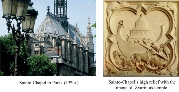
It is interesting to note that the themes about the Flood and Noah’s Ark were discussed in European medieval architecture, too. Thus, on one of the high reliefs of Sainte-Chapel in Paris (13th c.) Noah’s Ark is depicted. Behind it is the three-storey temple of Zvartnots (7th c.), which shows the relation between Noah’s Ark and Armenia.
As we see, even not being an independent state, Armenia has always been indicated on the maps until the 2nd half of the 19th c. In medieval cartography Earthly Heaven was always indicated in Armenia. The symbols of Armenia, Mount Ararat, Noah’s Ark, etc. were also indicated on the maps. The name Armenia was usually written in between the springs of the Tigris and the Euphrates Rivers.
It was usually indicated with the following names as well: Greater Armenia and Lesser Armenia. In all ancient maps Armenia occupies a central position. The study of the maps allows us to say that the Armenian Highlands and its surrounding territories, including Cilicia and Northern Mesopotamia, were populated with hay-armens, Armenian (Arian) tribes.
Armenia has existed since ancient times. Changes of Armenia’s borders within centuries are also seen on the maps. It is also known that many countries and empires (Sumer, Akad, Hittite State, Babylon, Assyria, Egypt, Roman Empire, Arabic Caliphate and Byzantine Empire) were formed and collapsed in the neighbourhood of Armenia during millennia.
The maps show the important role Armenia has played in world history during centuries. It used to be on the crossroads of commercial trade and one of the cradles of World Civilization. It should also be mentioned that European monarchs of the Middle Ages as well as political fi gures treated Armenians and Armenia benevolently.
Today, after several millennia, we can say that Armenians lived on the territory of their ancient Homeland (unfortunately, what is left of it is only a small part of Historical Armenia. Today’s territory of the Republic of Armenia is the smallest among the States Armenia has ever formed). Armenia is the only country in the world that is indicated both on the ancient Babylonian stellate map (6th c. B.C.) and on the maps of the 21st century.
An excerpt from Angela Teryan’s book “Ancient written sources of European peoples about their ancestral homeland – Armenia and Armenians”
114 Maps by R. Galchyan ‘‘Armenia in World Cartography’’, Yerevan, 2005, websites (according to the map names)