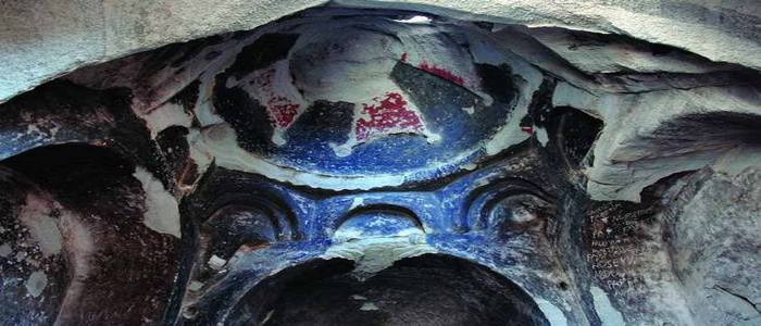
Not far from the village of Chukuraia (modern Turkey), 5 kilometers from the city of Kechror (Gabeganq, Ayrarat province of Greater Armenia), the ancient Armenian monastery complex Tsarakar was discovered. Only ruins remain from this monastic structure, unfortunately.
The complex consisted of a church, which had several entrances connected to each other, at least six chapels, a refectory, and cells for monks. Armenian inscriptions are visible on surviving stones, but until recently, neither experts nor topographers have ever paid attention to this.
It was only in 1999 that the monument was first visited by Scottish explorer Steven Sim who photographed it and made its schematic plan. Seismologist Shiro Sasano later visited the monastery and published several research papers covering it in 2009.
These two foreign researchers discovered the rocky monastery and made it famous in the scientific world. But they did not manage to find out the name of the complex at first – they only did so in a neighboring village inhabited by Kurds.
Realizing the importance of comprehensive research of this monastery complex, a commission for the study of Armenian architecture conducted scientific expeditions and published a wealth of information about Tsarakar in 2010.
Available sources indicate that Tsarakar is mentioned in medieval records, but its whereabouts remained unknown until recently. Once a major monastic complex in medieval Armenia, Tsarakar lost its glory and significance over the centuries and was consigned to oblivion.
At the end of the 19th century, Ghevond Alishan, using available sources, pointed out the areas where the lost monasteries, including Tsarakar, could be located.
The monastery is also mentioned in some works of historiographers and geographers. It was described to be located in a naturally inaccessible place in the immediate vicinity of Kechror.
Historian Yeprikyan came to the following conclusion: “Presumably, this monastery was formerly located in Gabeganq, Ayrarat province of Greater Armenia.”
Geographical research, starting in 1656, also confirms that this area is home to fortresses Kaput and Artagers and that the Tsarakar monastery is located on a cliff. Archimandrite Khachatur Kecharetsi is also said to be buried in the monastery.
These notes confirm two extremely important facts – firstly, the monastery was carved into a rock, and secondly, it was located near the city of Kechror.
Khachatur Kecharetsi was a priest and poet who lived between the 13th and 14th centuries. As evidenced by a note on a map compiled by Jeremiah Kumurdzhyan-Chelebi in 1691, he was buried in Tsarakar.
The etymology of the toponym “Tsarakar” is also important for its identification. Each visitor can easily see that the structure of the monastery complex is divided by masses of rocks of a certain color, similar to tree rings that indicate the age of trees. Apparently, the name “Tsarakar” means “a monastery that cut into a tree-like stone”.
Material from: Alexander Bakulin