To the southeast of the two-headed Masis – Ararat and the province of Maseatsotn, lies another province that is extremely significant for the history of Armenia, namely – Artaz, in the ashkharh of Vaspurakan of Greater Armenia.
At present, the territory of the Artaz province is part of Iran, occupying the northern area bordering Nakhichevan, part of the ostan (in Persian, this is a province, equivalent to the Armenian Vostan) of Western Atrpatakan (in Persian – Adarbaiyegan).
The capital of the province was the city of Maku. According to Movses Khorenatsi, both the province and the city were originally called Shavarshan or Shavarshakan, and the name Artaz was given by settlers from the similarly named province of Aghvanka.
The name Artaz (and its variations – Artazakan, Artash, Artvaz) is associated with the names Artashes and Artavazd from the royal dynasty of Artashisyan of Ancient Armenia. But there is also an obvious connection between the toponyms Artaz and Ardost-Artos-Ardushsha, which are quite frequently found on the map of Armenia, and this is already the most ancient root “ard”, associated with the concepts of fertility and productivity.
Artaz occupies the basin of one of the major right tributaries of the Araks River – this is the Maku River, which has a rather complex hydrographic network.
Maku itself originates from the Ain Mountains – an offshoot of the Vaspurakan or Kotur range, which now serves as the border between Iran and Western Armenia, and flows northward. Immediately before the city of Maku, which lies on its left bank, the river receives large tributaries from the west, from the Vaspurakan range, the Karmir and Avedzhukh (Abadjik) rivers, and from the north – the Arun River, which begins from Lake Gaylatu, which, after passing through the Kogovit swamp near Daroynka-Bayazet, receives many of its tributaries and flows towards Maku under the name Grnavuk.
Joining together, all these rivers flow eastward with two arms and flow into the Araks River opposite the historical city of Arkashat – now Shahtakht in Nakhichevan. The left northern arm is called Deghin – Yellow River, or Sarysu in the Turkic translation.
The right southern arm is actually Maku, or, in the lower course, Zangimar. Why do I dwell in detail on the hydrography of a single river? The fact is that one of its names has been fateful in the history of Armenia, while for many years it remained one of the mysteries of Armenian geography.
May 26, 451 AD. According to the testimony of a participant and chronicler of the Vardanants War, the 5th-century Armenian historian Yeghishe, on this day the battle between Armenian and Persian troops took place, which entered history under the name of the Battle of Avarayr.
Over time, this name has become a common noun, denoting the great, fateful battles of our people. But where did the Battle of Avarayr take place? It seems that Yeghishe provides a comprehensive answer – in the Artaz province, on the banks of the Tghmut River, near the village of Avarayr, on the Avarayr or Tghmut field.
But how many disputes were broken by Armenologists when localizing this field? They searched for the Tghmut River and Avarayr everywhere – they reached as far as the city of Khoy or Jera, although Yeghishe clearly set the geographical framework for the search – the Artaz province.
In the end, almost all researchers began to converge in the correct direction – the Avarayr field should be localized on the right bank of the Maku River in its upper course, 6-8 km southeast of the famous Surb Tadevos monastery, in the intermountain valley, which now bears the name Hovadjik (in Armenian Hovit, meaning river valley).
As for the Tghmut River, Yeghishe meant not the name, but the characteristic of the river – tghmut, i.e., silty. And this is exactly the nature of the Maku River; its lower arms are named Deghin and Zangimar – Yellow and Swampy, precisely because of their siltiness.
Moreover, the use of modern topographic maps provides us with another piece of evidence in favor of such localization: slightly downstream of Maku or Tghmut Maku, on its right bank, 5 km north of the Surb Tadevos monastery, lies the village of Abara Bashi.
I believe that this name is a distorted version of the toponym Avarayr, and Bashi, Bash in Turkic translation means Upper, head. Further downstream are the villages of Emam-Qoli-Pain and Emam-Qoli-Bala – all three villages, according to my assumption, bore the historical names Upper Avarayr, Avarayr, and Lower Avarayr.
Finally, east of the Avarayr-Ovadjik field is the village of Ali-Mardan. Perhaps “Mardan” is associated with the name of the Mard tribe, although their settlement area lies much further west, in the foothills of the Vaspurakan ridge, and is called Bun Mardastan (Nest of the Mards, Central or Main Mardastan).
Or, what seems more correct, we need to restore this toponym in the form of Ali – the Armenian Surb or Saint Vardan, and then it becomes clear where exactly Vardan Mamikonian was buried (at least initially).
Associated with the period of the Vardanants and Vahanants liberation wars are two more villages of the Artaz province. In its central part, 12 km northeast of Maku, on the left bank of the Deghin or Sarysu branch, lies the village of Yeghind or Irind.
In 484 AD, when negotiations were held between Vahan Mamikonian and the Persian military leader Nihor, which culminated in the signing of the Nvarsak peace treaty, it was in this village that Vahan Mamikonian’s camp was located.
Two years earlier, in 482 AD, near the small village of Nersehapat, located in eastern Artaz on the Arax plain, Vahan Mamikonian fought the Persian troops, resulting in a brilliant victory for the Armenian forces. It was the victory at Nersehapat that became the guarantee of the Nvarsak truce.
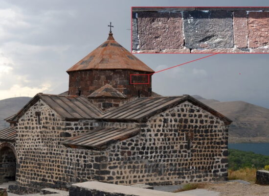
Alongside Avarayr, the main symbol of the Artaz province, and indeed of all Armenia, is the Surb Tadevos Monastery or the Main (Senior) Monastery of the Apostle Tadevos. Briefly called Surb Tade, this complex, together with Etchmiadzin, Tatev, and Gandzasar, is today one of the most visited and flourishing of our monasteries.
Thanks to the state care of friendly Iran, the Surb Tadevos Monastery is not only fully restored and operational, but since 2008 it has been one of the three Armenian monuments in Iran included, at its initiative, in the UNESCO World Heritage List.
Surb Tade is located near a village of the same name (the local name is Kareh Kilisa, or Black Church), on the right bank of Tghmut Maku, as noted above – 6-8 km northwest of the Avarayr-Ovadjik field. By the way, to the north of the monastery lies another small field – Tay Zavar.
This intermountain valley was the main place for the falcon hunting of Armenian kings and princes, also called Bazudzor – Falcon Gorge. The translation of this toponym is mentioned by the European medieval traveler Francesco Pegolotti – Plana di Falkonieri, i.e., Falcon Hunting Field.
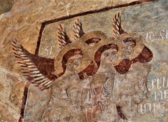
The Surb Tadevos Monastery was built in the 5th-9th centuries, on the site of a destroyed pagan temple, where in the 1st century one of the apostles who spread Christianity in Armenia, Saint Tadevos (Thaddeus), was buried.
According to tradition, it was here that Vardan Mamikonian was finally buried in the 5th century. The combination of yellowish-blue and black hues in the monastic complex gives this ancient structure a unique charm, and the black-and-yellow striped design of the dome of the old church makes Surb Tade a unique and recognizable monument.
Every year in July, the active monastery welcomes thousands of Armenian pilgrims from all over the world. In addition to the main complex, the monastery also owns the chapel of Tsorcoru Surb Kuyis Mariam, located 17 km downstream along the river, near the village of Barun – the Tsorcorskaya Chapel of the Immaculate Virgin Mary.
This is the second Armenian monument in Iran listed as a UNESCO site. When building a reservoir on the Tghmut Maku River, the chapel was carefully measured, its stones numbered, and restored in a new, higher location.
In the Middle Ages, the Surb Tadevos Monastery and the Tsorcorskaya Chapel were among the most significant centers of Armenian thought and literature. Ovannes Yerznkatsi, Bishop Zakaria, scribe Aristakes, and many other distinguished Armenian minds lived and worked here. In the vicinity of the monastery, five more Armenian chapels have been preserved.
Also significant in the early Middle Ages was the Atsyunats Surb Nshan Monastery near the village of the same name (now Atsyun or Asin Bozorg (Large)) in the north of Artaz, in the foothills descending from Sisa (Little Ararat) of the Tambats-Artaz Mountains.
Sebeos, Tovma Artsruni, Ovannes Draskhanakertsi, Vardan Areveltsi, and other historiographers mention it. According to the traditions they cite, part of the relics of Christ was kept in the Atsyunats Monastery.
In the far north of Artaz lie the lakes Ahi or Al, Large and Small, separating Artaz from the Maseatsotn province. In the village of Horinants on the southern shore of Small Ahilich, the Surb Astvatsatsin Church is located – one of the centers of Armenian medieval literature.
The capital of Artaz, the city of Maku or Shavarshakan, lies on the left bank of the Maku River at its eastern turn. The city is located like an amphitheater on the steep slope of a bottomless gorge and is famous primarily for its impregnable fortress, which belonged to the Amatuni family. In the fortress, a cuneiform inscription of the Urartian king Rusa II about the construction of the Haldi temple has been preserved.
To the east of the city stands the lone rock Sartzali – with the help of the cold wind blowing in the summer, ice was obtained here in the past. In the complex of the Maku fortress is the rock-hewn church Surb Vardan. A small number of Armenians live in Maku and in the village of Surb Tade even today.
by Grigor Beglaryan
Translated by Vigen Avetisyan