So, returning to the interrupted discussion about maps, we, as promised, will introduce readers to several examples of medieval Armenian maps. Only a very limited number of scholars have professionally dealt with the history of Armenian cartography.
In 1957, H. Stepanyan published the monograph “Armenian Cartographic Publications for 260 Years (1695-1955),” in which he first attempted to systematize and scientifically describe Armenian printed maps.
During the years of post-Soviet independence, some researchers and collectors (K. Mutafyan, R. Galichyan, etc.) published colorful atlases with Armenian and foreign ancient maps. Finally, G. Uluhogian, who discovered the famous map of Jeremiah Keomurchyan (1691) in the library of Bologna University in 1991, dedicated a separate monograph to it.
In one of the Armenian manuscripts of the 13th-14th centuries, stored in the Matenadaran under number 1242, an interesting map is placed. This anonymous world map in Armenian, belonging to the so-called T-O type, is one of the oldest discovered Armenian maps.

I repeat, we know for sure about several even older maps, created in the 7th century by Anania Shirakatsi, as well as a globe created by him, but they have not yet been found. The T-O map of the Armenian manuscript belongs to the period when all European cartography followed the principle of creating circular maps of the world – with Jerusalem at the center and Europe, Asia, and Africa (more precisely, its northeastern part) divided in the form of the letter T.
Before us is an example, illustrating the fact that Armenian scholars and scribes also did not remain aloof from this not very scientific tendency. However, to the same 13th century also belongs another Armenian map – much more progressive for its time and highly artistic in finish.
We are talking about a miniature, placed in one of the Armenian manuscripts of 1286 (under number 979 in the Matenadaran). The authorship of the artistic design of the manuscript, and accordingly, of the map, is attributed by researchers to the famous Armenian miniaturist, a representative of the Cilician school, Toros Roslin.
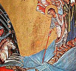
The miniature is titled “Crossing the Red Sea” and depicts the Biblical episode where the Jews, led by Moses-Movses, crossed the Red Sea on dry land between the parted waters.
Clearly depicted for its time before us is the Sinai Peninsula, washed by the Suez and Aqaba gulfs from the west and east, respectively. In the miniature, the Jews have already reached the peninsula, and the pursuing Egyptian army stands before the closed waters of the Suez.
The same scene is depicted, for example, in the “Christian Topography” of 1535, nearly two centuries later, authored by Cosmas Indicopleustes (“Crossing the Black Sea”), much more schematically and mediocre even from an artistic point of view.
As for the artistic execution, the Cilician and Vaspurakan (Van) Armenian schools of miniatures are recognized worldwide as some of the most advanced medieval schools.
And Toros Roslin (like any other author from Cilicia), of course, was well acquainted with the geography of the Middle East and the Promised Land, which directly adjoined Armenian Cilicia.
By the way, one of the first Armenian maps, published by printing method in Venice by the Congregation of Armenian Mekhitarists in the 18th century, was precisely a map of the Promised Land, or in Armenian, “Yerkir Avetevats.”
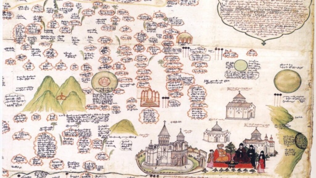
The map of Jeremiah Keomurchyan, discovered in 1991 at Bologna University by Gabriella Uluhogian, is exceptional in its informativeness and significance for the history of the Armenian Church.
It is called the “Map of the Armenian Catholicosates” and was created in 1691 by the famous scholar and historian Jeremiah Chelebi Keomurchyan, commissioned by the diplomat from Bologna, Count Lodovico Marsili.
The epithet “Chelebi” (noble, aristocratic) was given by the Turks to outstanding figures of science and culture. The work of J. Keomurchyan, “Ashkharagrutyun” (“Geography”), unfortunately, has not reached us (or has not yet been discovered).
It contained invaluable information about Armenia, its geography, and its numerous monasteries. Only the preface and the map have been preserved. Measuring 3.5 by 1.2 meters, the “Map of the Armenian Catholicosates” displays all the churches and monasteries in the territory of Historical Armenia, which was then divided between the Ottoman Empire and Persia.
The color scheme of the monasteries and churches indicates their affiliation with a particular Armenian Catholicosate – Echmiadzin, Sis, or Aghtamar.
Significant monastic complexes are presented on the map as graphical images, representing both artistic value and an exceptional example of so-called “landscape cartography.”
The territory depicted on the map covers all of Historical Armenia – from the Caspian Sea to Constantinople. In the corner of the map, a brief history of Armenia is provided as a legend.
The map of Jeremiah Keomurchyan holds exceptional value both for the history of Armenian geography and cartography, and for the general understanding of Armenia in the 17th century, divided between Persia and the Ottoman Empire, with its faith and culture that continued to develop despite everything.
It also vividly demonstrates the number of churches and monasteries in Armenia—a country that was the first to adopt Christianity—which the Turks are forcefully trying to reduce and eliminate.
Even after the invention of printing and after the publication of several dozen printed Armenian maps and atlases, Armenian cartography naturally returned again and again to the depiction of Armenia, to the mapping of its historical homeland.
Published in 1787 by the Mekhitarist Congregation in Venice, the Armenian map of the Ottoman Empire is quite accurate in geographical terms. It is one of the first examples of cartography in the Armenian language for the entire region.
by Grigor Beglaryan
Translated by Vigen Avetisyan