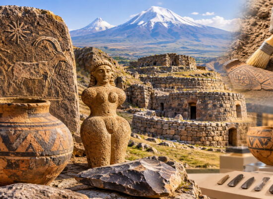
Armenia has been on maps for almost three thousand years. The earliest image we know is a Babylonian clay tablet of the 7th–6th century BC, where Urartu is labelled. After that came Ptolemy’s maps marked “Armenia Maior”, a Roman road map, European atlases, and in 1695 the first map printed in Armenian letters, in Amsterdam. Let’s go through them in order and see where the originals are kept and which images can be used on a website.
The Babylonian Map of the World: Urartu on clay
The oldest surviving map that shows our region is the Babylonian Map of the World. The clay tablet was found at Sippar (modern Iraq) and is dated to somewhere between the late 8th and the 6th century BC. It reached the British Museum in 1882 (inventory number BM 92687) and was read in 1889. The world is drawn as a circle: the Euphrates and Babylon in the centre, a ring of water around the edge. Few regions are labelled, and among them is Urartu (Akkadian Urashtu), north of Assyria. A full list of the labels is in the article on the map.
The word “Armenia” is not on the tablet yet. What is labelled is Urartu, an Armenian state on the Armenian Highland that preceded the later kingdoms of Armenia. The tablet measures 12 by 8 centimetres and holds only a handful of regions; Urartu stands among them next to Assyria.
Ptolemy and “Greater Armenia”
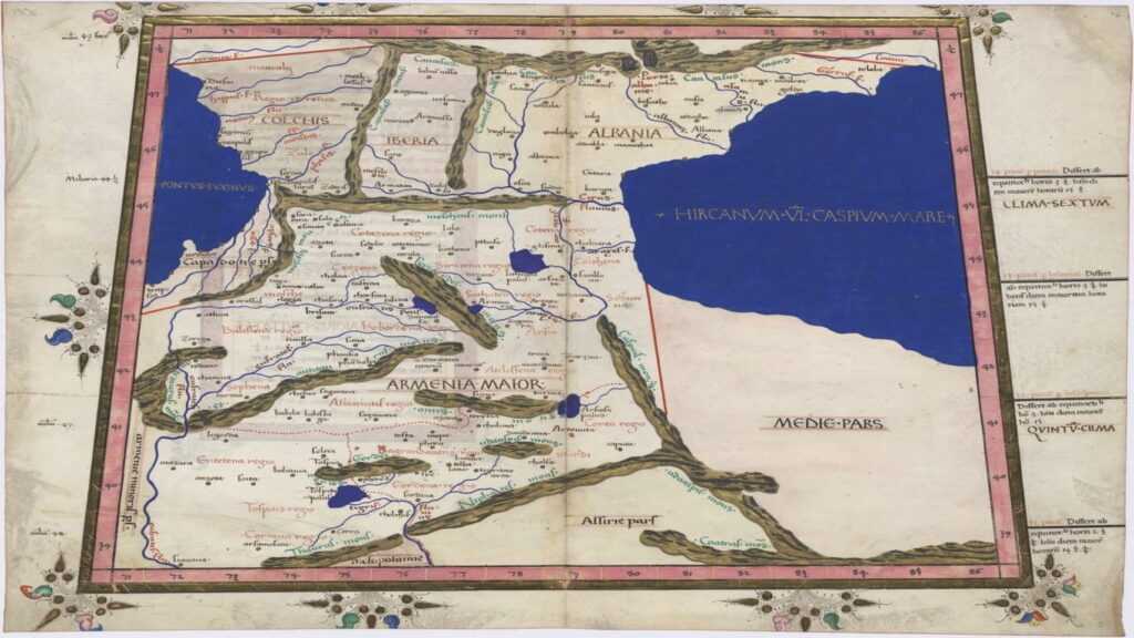
In the 2nd century AD the Greek geographer Claudius Ptolemy compiled the Geography, a set of coordinates for thousands of places. Armenia fell on the third map of Asia, together with Colchis, Iberia and Albania; in Latin the map is called “Armenia Maior, Colchis, Iberia, Albania”. But we do not have Ptolemy’s own maps. The earliest Greek manuscripts date to the 13th century, and everything we see today is a later copy (more in the article on the Geography).
One of the fullest copies is in the British Library: the manuscript Burney MS 111, 15th century. Other copies of the third map of Asia are in the National Library of France, the New York Public Library and the Bodleian Library in Oxford. The parchment Cosmographia of Nicolaus Germanus (1467) from the Polish National Digital Library belongs here too. All these sheets are collected in the category Ptolemy’s 3rd Asian Map on Wikimedia Commons.
The Roman road map
The Tabula Peutingeriana is a scroll about seven metres long showing the roads of the Roman Empire from Britain to India. It goes back to a 4th-century map, and the surviving copy was made about 800 years ago. It is kept in the Austrian National Library in Vienna and has been on UNESCO’s Memory of the World register since 2007. Amayak Martirosyan wrote about Armenia on this map: “Armenia on the Peutinger Map (4th c.)”. The segments can be viewed on the Euratlas site, which publishes them with the library’s permission.
The Ashkharhatsuyts: a geography written by an Armenian
The 7th century gave us the first Armenian geography, the Ashkharhatsuyts (“Showing the World”). It is usually attributed to Anania Shirakatsi and dated to 610–636. For the history of Greater Armenia it is a very important source: it lists the regions, mountains, rivers and cities of the country on the eve of the Arab conquests. We know of no other Armenian geographical work before the 13th century (article on the Ashkharhatsuyts, Ananias of Shirak in Encyclopaedia Iranica). The author took his description of Europe, Africa and Asia from Pappus of Alexandria, who in turn relied on Ptolemy.
The Ashkharhatsuyts itself is a text, not a map. The maps “after the Ashkharhatsuyts” that historians work with were drawn later, for example Suren Yeremyan’s map (1963), which is also the basis of an analysis of Shirakatsi’s mathematical problems. The manuscript is among the oldest geographical books in the Matenadaran.
European maps of the 16th–17th centuries
Once Latin editions of Ptolemy appeared, Armenia became a regular guest in European atlases. On Ortelius’s “Black Sea” map from the Parergon (1624) it is labelled “Armeniae Pars” and sits next to Cappadocia, Colchis and Albania (file on Commons). In Ruscelli’s 1561 edition, Ptolemy’s map is drawn with Armenia at the centre. And Mercator’s Geographia (1578; reissued in Amsterdam from 1695) has a map of Armenia, Georgia, eastern Turkey and southern Russia.
A whole book has been written about Dutch maps of Armenia, Armenia in the Ancient Dutch Maps. It contains about fifty maps and ends with the first map published for Armenians in 1695 (presentation at the Armenian Embassy in the Netherlands).
The first map in Armenian
In 1695 in Amsterdam the printing house of Tovmas Vanandetsi issued the Hamatarats Ashkharhatsuyts: a world map in two hemispheres with all names given in Armenian. It was engraved by the Schoonebeck brothers. The map consists of eight sheets that together measure 150 × 120 centimetres (description on Google Arts & Culture). It is the first map ever printed in Armenian. Reduced versions appeared later, for example a Venetian one of 1747 and an early 18th-century copy at the Leventhal Map Center in Boston.
Then the centre of Armenian printing moved to Venice, to the island of San Lazzaro, to the Mekhitarists. There, in 1786–1787, Hovsep Endasian’s maps came out (Asia, Africa, Europe, America); they are kept in the Library of Congress (entry on the library’s blog). The National Library of Armenia has a “Map of Armenia” (Venice, 1778) and other early printed maps (collection description).
The 20th century
After the First World War, maps of Armenia became political documents. In 1920 Zadig Khanzadian’s Atlas de géographie historique de l’Arménie appeared (it is mentioned in a selection of historical maps of the Caucasus). That same year US President Woodrow Wilson determined the border between Armenia and Turkey; the map of that border is kept in the Library of Congress. The same library holds a plan of Yerevan from around 1920.
Where to find the originals
| Institution | What to look for |
|---|---|
| British Museum | Babylonian Map of the World, BM 92687 |
| British Library | Manuscript Burney MS 111 with maps after Ptolemy |
| National Library of France | “Asiae Tabula III” after Ptolemy (Gallica) |
| Bodleian Library, Oxford | “Eastern Turkey and Armenia” |
| New York Public Library | Third map of Asia after Ptolemy |
| Austrian National Library | Tabula Peutingeriana |
| Library of Congress | Armenian maps and atlases (Armenian Rarities), Endasian’s maps, the Wilson map |
| National Library of Armenia | The first printed map in Armenian (1695), “Map of Armenia” (1778) |
| History Museum of Armenia | Exhibition “Armenia in Historic Maps, 6th c. BC – 19th c. AD” |
| Matenadaran | Manuscripts of the Ashkharhatsuyts (website) |
| David Rumsey Map Collection | “Carte de l’Arménie” |
Which images can be used on a website
| Image | Terms |
|---|---|
| Ortelius, map of the Black Sea, 1624 | Public Domain Mark: free to use |
| Boundary between Turkey and Armenia as determined by Wilson, 1920 | Public domain (a document of a US government agency); original: Library of Congress |
| Plan of Yerevan, c. 1920 | Public domain in the US according to the tag on the file page |
| Third map of Asia, Nicolaus Germanus, 1467 | Free file on Commons; source: Polish National Digital Library. The file name says “Central Europe”, but according to its description it is the map of Greater Armenia, Colchis, Iberia and Albania |
| Sheets of Burney MS 111 (British Library) | Uploaded to Commons by the British Library; terms are given on each file’s page. Size about 40 MB |
| Babylonian Map of the World | The British Museum model is licensed CC BY-NC-SA 4.0: non-commercial use only |
| Tabula Peutingeriana | Files in the Commons category; terms are given on each file’s page |
Caption images in full: the institution, the shelfmark or title, and the source of the file. For example: “Map after Ptolemy, British Library, Burney MS 111; Wikimedia Commons”. A map in a 15th-century copy should not be called a “2nd-century map”: Ptolemy made it, but it has reached us only in later manuscripts. Files from Commons weigh tens of megabytes, so it is better to put a reduced version on the page.
Sources
- Babylonian Map of the World, Britannica
- Babylonian Map of the World, Wikipedia
- Geography (Ptolemy), Wikipedia
- Category: Ptolemy’s 3rd Asian Map, Commons
- Tabula Peutingeriana, UNESCO
- Ashkharhatsuyts, Wikipedia
- Ananias of Shirak, Encyclopaedia Iranica
- Hamatarats Ashkharhatsuyts, Google Arts & Culture
- Endasian’s Armenian maps, Library of Congress
- Armenia in Historic Maps, History Museum of Armenia
- Map of the Armenia–Turkey boundary (Wilson), Library of Congress
Title illustration: Map based on Ptolemy, British Library, Burney MS 111; Wikimedia Commons