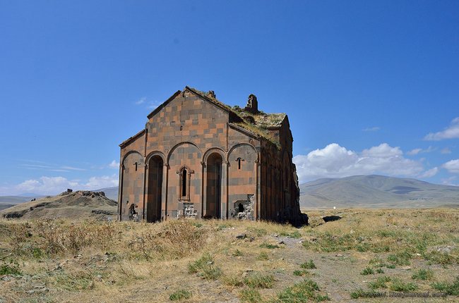
 In 45 km from Kars, on the very border of the Republic of Armenia are the ruins of the once great medieval city of Ani, the capital of the Ani kingdom. The history of this city has been well studied and a numerous articles and books have been written about it.
I will highlight only some episodes of modern history that took place in the twentieth century, and which I managed to learn about. And I’ll also tell you about some Turkish lies.

The date of foundation of Ani is lost in the depths of centuries. Between 5th and 8th centuries it was in possession of the princes of the Kamsarakans, and then the Bagratids. In 961, the Armenian king Ashot III brings the capital from Kars here.
The city reaches its apogee, as it was inhabited by more than 100 thousand people. Then, in 11th century, control over Ani was taken by Byzantium. Subsequently the city was captured by the Seljuk Turks, after some time by Kurds, then by Georgians, again by Seljuks. In 13th century it was ruined by the Mongols, thus giving a start to the fall of Ani.
In 1319 a strong earthquake destroyed many urban buildings. In 1534 the city was captured by the Ottoman Empire. In the period from 1878 to 1917, Ani has been a part of the Russian Empire. During over its thousand-year history the city was destroyed by multiple earthquakes. However, the Kemalistic regime of Turkey made the most contribution to this matter in 20th century, but more on this later.
During 19th century the first archaeological researches of this ancient city have begun. Ani was located on a large triangular plateau between the border river Akhuryan and its tributary Ani. From one side the city was defended by now half-ruined, but undoubtedly powerful fortress walls. Those appeared first when we drove close to there. The only thing left by the main gates was devastation:


Entering Ani, you can see a huge desert plain, on which separate buildings, mostly ruined, are standing.

The walls aren’t so imposing from the inside. The round towers “are opened like shells of oysters and opened their stone wombs from the top to the heels,” as Russian traveler and publicist Eugene Markov wrote at the very end of 19th century.

The first sight was the only surviving wall of Georgian church, built presumably in the 11th century. Most of the church’ building collapsed in 1840.

The entire territory of the huge fortress is strewn with stones, the remains of ancient buildings:

In some places the foundations of ancient houses can be seen protruding from the ground:

There is practically nothing left from the once majestic round church of St. Gregory the Illuminator, also known as the church of King Gagik. Only the circle of the foundation and the bottom of the supporting column are sticking out.

At this point you can only make guesses about the former grandeur and scale of this structure.

Caps of columns, lying among the ruins, amaze with their size and weight. How much work was invested in the creation of these monuments! And what power was needed to destroy them!


Closer to the steep bank of the river, or rather, the stream of Ani, is a rock of tuff with a plurality of caves. According to a legend of ancient times, here was an underground passage to Kars! In some places along the cliff there were also defensive walls of the city.

On our way every now and then we met evidence of the attitude of Turks to the historical monument, which they proposed to be included in the UNESCO World Heritage List.

The Church of St. Gregory of 11th century was preserved almost completely.

Armenian texts on the church’s wall:


Modern Turkish arts:

The interior of the church:

Ruins of old Armenian baths:

And now I will tell you something that you, dear readers, might consider quite fantastic. Here are the ruins of another church, name and the date of construction of which I wasn’t able to find.

Here is a fragment lying in a considerable distance from the church:

Now the story itself. When we were driving up to Ani, one of my companions told me that in 1950s Turks had staged a tank training ground in Ani.
I didn’t believe him then. He told me that when he had been here a few years ago when he met an elderly local resident, who was a child when trainings had occurred.
The resident told him that once he had seen several dozens of moving and shooting tanks. As I said, this is the very border with the Republic of Armenia, and back then it had been, a border with the USSR. What conclusion would probably most of us make in this situation?
Correct answer would have been that the Soviets began an invasion. The same thought occurred to this man. He threw his sheep, ran to the road, caught a bus and rushed to Kars to the military, screaming that Ani had become tank battlefield after an attack by Soviets.
He got this answer: “Calm down, boy, go home, we are aware of it, that is a teaching.” This guy then asked: “How can the exercises take place at an archaeological complex?” He was simply told that it was none of his business.
And now once again we look at the ruins of this nameless church.

There are no craters, but there are traces if fire on the church’ remains. But what could inflame in stone ruins?
Let’s continue our tour of the ruins of Ani and head to the Inner Fortress, a citadel located on a hill.

On the way we see ruins of several churches and chapels. They are nameless on all historical schemes of the city.


Ruins of citadel’s walls. In general, little is left of it. Mostly, just piles of stones.


Citadel’s wall from the side of the river Akhuryan.

A view of the Surp Stephanos church from the citadel. It is located on a rock beautifully bent by a river. It’s a pity we did not manage to get there…

A view of the canyon of the Akhuryan River and ruins of an ancient bridge, along which the Great Silk Road had passed. On the right, in the distance, a border military base of Armenia was visible. Unfortunately, Armenians can only observe their ancient capital from afar…

The Manuchihr Mosque. The opinions of historians differ on the date of its construction. The Turks claim that the building was originally built as a minaret in 11th century, when Seljuk Turks captured Ani. However, there are other versions stating that the building was originally a church or a residence of the Catholicos, and the Turks only attached a minaret to it.

In fact, when we went into the “minaret” and looked up, we saw crosses. In addition, the minaret, both in appearance and in the opinion of scientists, strongly disagrees with the building.

Majestic Cathedral of Ani. Its construction was completed in 1001. Later, in 11th century, when the Turks seized the city, the cathedral was turned into a mosque. Turks removed the cross from it and buried it at the entrance, so that those who entered would trample it. In 12th century the cathedral was reclaimed by Christians.
The earthquake in 1319 severely damaged it. The dome of the Cathedral collapsed and was abandoned. Now the Turks plan to restore it in form of a mosque. Under this case they are trying to find funds from UNESCO. In 2010 there was even a Friday salah (“Muslim prayer”). It’s terrible.

The interior. It would be an understatement to say that the cathedral is huge. Pay attention to the two lower wider rows of stones. The height of these two rows is half of human height.


I wonder, what are they going to do with the Armenian religious texts on the walls of the cathedral?

Active archaeological excavations being performed near the church.


Right before my eyes a fragment of Armenian text was extracted from the ground. Turk workers started to take photos of it. I also approached to take one as well. Turks immediately began to grumble, saying it was not allowed.
I just shrugged and went on. But now I am pleased to publish this artifact. Most likely, this does not represent any special significance, but, nevertheless, you might see this for the first time.

A number of fragments of a building with Armenian decor are next to it.

Once again, let’s admire the beautiful construction of the Middle Ages, which, even in ruins, has not lost its majesty.
The Church of the Savior was built in 1035. Approach to it is covered with barbed wire, so I took a picture of it only from afar. At that time, I did not yet know that only half of what you see was left of the church.
On the other hand, it is like “an open half of an oyster” as well. It has been stated that in 1950 that a lightning hit the church and destroyed half of it. Were they trying to explain traces of burning on the remains? I kept trying to find images of destruction of buildings by lightning on the Internet, but I couldn’t find anything.

We returned to the center of Ani along its main street, or rather along the path that had been once the main street. By the way, there was an ancient water pipe under it!

The street leads us to the destroyed minaret.

I also forgot to mention that there were Turkish information signs across Ani. I just took photos of those without reading. At home, during examination, I noticed a sign near this fallen minaret.

On their bad English Turks are informing us that in the beginning of 20th century an Armenian priest blew up the minaret. This lie is so absurd that it seems ridiculous to try to refute it.
However, you can’t leave it that way. Simple tourists, onlookers who came here on an excursion will easily believe this inscription as they are used to trusting hundreds of descriptions of attractions around the world. Then they’ll return home, tell friends the “information”, and it will spread like a wild fire. It is easy because people sometimes know so little that, for example, information about genocide of Christian nations takes them by surprise.
Let’s try to figure out what happened after all. Well, firstly, the beginning of 20th century is not so ancient to indicate it so rudely. Secondly, what kind of “Armenian priest”? What’s his name?
And what were motives for such an action? Turks don’t tell anything to us. However, anyone can easily find information about this on the Internet. The Russian traveler Yevgeny Markov, who has been quoted here many times, comes to the rescue.
The minaret with Kufic lines was not the only one in Ani. Judging by the atlas of the ruins of Ani, published in 1860 by a well-known archaeologist and connoisseur of the Caucasus, Marie-Félicité Brosset and genuine pictures of Kestner, in the middle of Ani, not far from the main cathedral, there was still another similar, but even taller minaret. It was seen few years ago by our other companion, but it has been already crushed to dust and scattered around when we saw it.
Some say that this minaret was overturned by the last earthquake that destroyed or damaged high stone buildings in many localities of the Caucasus, and even in Tiflis (now Tbilisi, capital city of Georgia) itself, according to Markov’s article “Russian Armenia. Winter trip in the mountains of the Caucasus” published in May 1901 in Vestnik Evropy’s N0 5 (Russian “Messenger of Europe”).
There are people that will certainly say that local residents gave false information about the reasons of the fall of the minaret to Mr. Markov, and the “intelligent Turkish scientist” knows more. Well, let’s figure it out.
We do not know when Evgeni Lvovich has made his journey. The text was published in May 1901. Before that he still had to return, prepare a manuscript, go through censorship. Well, let’s even say that this was done in incredibly short terms and the journey can be dated 1900 in order to somehow excuse the Turkish lies about “the beginning of 20th century.”
So, according to the Turkish version, some crazy Armenian priest in the beginning of 20th century, but no later than 1900 (funny, isn’t it?) has done some digging, put down dynamite and for some reason blew up an abandoned minaret. But, in the same year Mr. Markov came to the scene, saw a fallen minaret and was told by local people that this had been a result of a long-standing earthquake.
Nothing is known to anyone about the “crime”, except Turks, our contemporaries. Let me remind you, that in those years this place was part of the Russian Empire. Under Russian laws for such an action, this priest would be exiled to Siberia and the press would certainly write about it even before Markov would have reached this information.
British, by the way, Turks’ allies at the time, reported that this minaret was destroyed in an earthquake in 1890. It quite suits the conditions of Markov’s trip. So, Turks should remove their cheap propaganda and explain why Armenian architectural monuments were shot during military training in 1950s.

Moving on. The ruins of another building, apparently, a church. The name of this is not known to me either, unfortunately.

Church of the Holy Apostles. The exact date of construction is unknown. The earliest Armenian inscription on the walls of the church dates back to 1036. It is known that the church has been built by Armenian noble family of Pahlavuni. Seljuks turned it into a stable after capturing the city.


Again, a very strange nature of destruction. I do not know when the photo presented here has been taken, but the destroyed part of the building is intact. And again we see traces of burning on the remains.


At last, Zoroastrian fire temple, the most ancient building of Ani, constructed in pre-Christian times.

Presumably, the Fire Temple was built in 1st century! How ancient is this settlement? And how many wonderful discoveries could real researchers make here?
One thought on “Ani, The Ancient Capital of Armenia”
What a wonderful ancient Armenien structure and architecture.. what a pitty, that these remains of an old and admirable culture do not get the respect of the Turks. Just like in Nachitschewan, where so many churches, grave yards and katchars just were destroyed because of ignorance and a stupid ideology of re-writing history…