Almost in the very center of Ashkhar Bardzr Hayk, in the west of Greater Armenia, lies the Gavar of Yekeghyats, representing the valley of the middle course of the Upper Euphrates. To the north, Yekeghyats is bordered by the ridges of Surb Grigor (Sipikor) and Ator Anahta or Keshishdag (Monk Mountains) of the Armenian Northern Tavros system, and to the south by the Mnatsur and Gaylakhazut mountains of the Byurakn-Mndzur system of the Armenian Inner Tavros.
To the east, Yekeghyats is closed off by the Derjansky bend of the Euphrates, and to the west, the gavar reaches up to the mountain massif of Daranagheats or Sepukh.
Yekeghyats is located on both banks of the Euphrates, which flows from east to west within the Gavar in a broad valley, overflowing abundantly during the snowmelt season and spring floods. Upon leaving Yekeghyats, the Euphrates enters the narrow and steep Kamakh Gorge.
It is precise because of the Euphrates floods, accompanied by the extensive swamping of its banks, that the Gavar of Yekeghyats got its name. The original form of the toponym is Yhekhats or Yhegheats, which translates from Armenian as “reed land” – various types of this moisture-loving plant cover the coast of the Euphrates along the entire Gavar.
In the absence of large forested areas, reed (yheg) played a huge role in the life of the local Armenians, serving as fuel and building material. Later, with the adoption of Christianity and the creation of historically significant monasteries and churches here, the name of the Gavar was reinterpreted as Yekeghyats.
This new meaning was borrowed by the Greeks, who called the gavar Ekilisene, and the word “yeghegits” (church) migrated both to Greek – “eklisia”, and much later, to Turkish – “kilise”. The Greek also has a similar sounding word for “yheg” – “elegy”, which became the basis for the later Turkish loanword “ilidje” – an analogue of the ancient Armenian “yhegi”.
The capital of the Yekeghyats Gavar is the city of Yerznka, which originally lay directly on the right bank of the Euphrates, where the two arms of the great river meet, forming the Euphratats island.
However, due to spring floods, extensive marshland development, and the bank’s overgrowth with reeds, and as a result of all this – an unhealthy climate and lack of drinking water, the city was moved several kilometers to the north from the Euphrates bank in the early Middle Ages – slightly upstream of its right tributary, Vaskerti Djur.
The ancient name of the city was Yeriza, which translates from Armenian as “edging” or “trimming.” Thus, the toponym is understood as “the city edged by the bank (of the Euphrates).” This etymology is quite common in the Armenian Highlands.
Later, with the adoption of Christianity, the root “erez” took on a second meaning – “erets” (priest), which again is often encountered in Armenia. In this case, the name Yeriza, after undergoing several changes, evolved into Yeriznka and then into Yerznka, giving rise to the common Armenian surname Yerznkyan.
Later in the Arabic language, the toponym sounded like Yerzingan, and in the Turkish distortion – Yerzindjan.
To the south and east of Yerznka, on the right bank of the Euphrates, stretches the vast plain of Yeriza or Yerznka. Along with its surrounding hills and heights, it is the most ancient sacred center of all of Armenia, where cities and temples have been built for ages, serving as the religious centers of our country.
On the summit part of the mountain Ator Atahta, rising to the northeast of the plain, was the main sanctuary in Armenia dedicated to the goddess Anait. Later, a church appeared in its place, and the mountain, bearing the ancient name “Throne of Anait,” started to be named by the Turks as the Monk Mountain – Keshishdag.
The mountain’s altitude above sea level is 3546 meters. At the foot of the Throne of Anait lies one of the most ancient Armenian cities – Dzmen or Tsumina, – now the settlement of Djimin (dialectal, including the Artsakh variant – Chumen).
6 km east of the city, on the site of another temple of Anait, is the monastery of Surb Nikoghayos, which played a significant role in the Armenian life of the Gavar until 1915.
Directly on the Yerznka plain itself, on a low hill on the right bank of the Euphrates, excavations of an ancient settlement have been underway since the 1960s. The Turkish Altyn-Tepe (Golden Hill) is just a later assignment, due to the frequent discoveries here of ancient gold artifacts.
The Turks themselves acknowledge that the ruins belong to an Urartian city, and according to some researchers, it refers to one of the cities founded by the Van king Argishti, named Argishtihinili.
A more plausible theory suggests that the settlement of Altyn-Tepe should be identified with the city of Pitteu or Pitteyarika of the land of Hayasa – Hayastan, mentioned in early Hittite cuneiform inscriptions.
Supporting this hypothesis is the name of the nearby ancient village Btarich (Piterich). And it, in turn, originates from the ancient Armenian roots “but” and “arich”, which are very productive in our toponymy.
“But” or “butak” means a round top with evenly diverging slopes – this term is also used to refer to the end of the neck of stringed musical instruments, where the strings converge, much like the threads of mountain valleys.
And “arich” is the ancient ending of many Armenian toponyms with the meaning of a sanctuary, a shrine, or a temple center – Btarich, Bagarich, Khakhtoarich, Kitarich, Arich (near Kumayri), and others.
So, we get a name that perfectly fits the ancient Hayasan city – Btarich, a temple at the base of a rounded top, in Hittite – Pitteyarika.
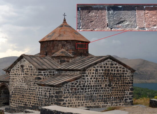
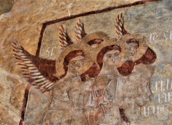
The ancient city of Yeriza (originally, on the bank of the Euphrates) also had a temple dedicated to Anait, on which, with the efforts of Gregory the Illuminator, the monastery Yerizu Surb Astvatsamor was built in the 4th century.
In general, the cult of Anait was one of the most widespread in ancient Armenia. It took such deep roots in our sun-born country that to this day the name Anait remains one of the most common Armenian female names, and the saddle between Masis and Sis is called Tamb Anakhta – Saddle of Anait.
Under the name Anaita or Anaida, this Armenian goddess was worshipped throughout Asia Minor – from Cappadocia to the Aegean Sea. From Phrygia, she then entered Ancient Greece – evidenced by many mountains in Hellas named Ida.
By the way, in Armenia, the name Anait underwent dialectal changes over the centuries, as a result of which there are also villages and mountains named Id in our country.
9 km northwest of ancient Yeriza, on the bank of the right tributary of the Euphrates – Gailgeta (not to be confused with the major river Gailget flowing within the Gavar of Kerchanis of Lesser Armenia) – is one of the earliest religious centers of Armenia, Til.
Here was the shrine of the goddess Nane, on which a church was founded in the early Christian period. It later became the Jukhtak Airapetats monastery, due to the burial within its walls of the first two Armenian Catholicoses after Gregory the Illuminator – Nerses Mets and Aristakes.
Later on, when their ashes were transferred to the Tirashen Monastery on the opposite–left bank of the Euphrates, the Til Church fell into decline and began to be called Angats Ekeheci – The Faded Church.
In general, in the Christian Armenian tradition, destroyed churches are very symbolically called either Angats or Khonarvats – Stooped. Avan Til (if you remember, the ancient Armenian “hill”, analogous to the Semitic Tell) continued to play an important role in Armenian history.
Here, in particular, King Pap was buried, whose ancestral estate and palace were located nearby, in another ancient avan of Ekeheats – the settlement of Hakh.
Another avan with the ancient name Vosketil is located further upstream of the Euphrates, on its left bank, at the eastern end of the Euphrats island – it seems that this toponym, translated from Armenian as Golden Hill, served as the basis for the later Turkic calque Altyn-Tepe – right opposite Vosketil.
With Armenia’s adoption of Christianity, the importance of Ekeheats as a religious and temple center of all Armenia did not fade, but rather, so to speak, reprofiled. The largest and most significant temples, throughout the country, were destroyed, but new ones were built in their place – now Christian.
However, they were “new” only for Armenia, which by that time had a history of more than three thousand years – for the rest of the world, this is the ancient grayness of the first centuries AD.
Another ancient city of Armenia – Tordan – shares a similar fate. Actually, Tordan is not located in Ekeheats, but in the neighboring western province of Daranakhi (land of salt mines) of the country Bardzr Aik, on the right bank of the Euphrates, not far from the city of Kamah, at the southern foot of Mount Daranaheats or Sepuh.
However, since the history of Tordan is closely linked to the life and activities of Gregory the Illuminator, we will visit it during this journey. So, in ancient times, there was a temple of the god Mher-Mithra in Tordan.
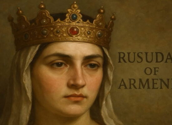
Gregory the Illuminator, having received this avan and its surroundings as a fiefdom in his later years, founded a monastery Surb Nshan on the site of the temple. While leading a hermit’s life on the slopes of Daranaheats-Sepuh, the Illuminator passed away and was initially buried in the Manea air cave near the peak.
Later, his ashes, along with the ashes of King Trdat III and his closest relatives, were reburied in Surb Nshan, which from then on was called Surb Nshan Inn Srbotc Vank – Monastery of the Holy Cross and Nine Saints.
As for the name Tordan, it translates from Armenian as “throne house” (Atortun) or “house by the water”, obviously referring to the most ancient layers of our ancient language.
by Grigor Beglaryan
Translated by Vigen Avetisyan